The Washington DC Metro Map is your essential guide to navigating the capital with ease. Covering six color-coded lines and nearly 100 stations, it connects key landmarks, neighborhoods, and transfer points like Metro Center and L’Enfant Plaza. Whether you’re a tourist visiting the Smithsonian or a daily commuter, this map ensures smooth, efficient travel across DC, Maryland, and Virgin.
Welcome To DC Metro Map
Navigating the nation’s capital has never been easier, whether you’re commuting to the office, heading to a Nationals game, or exploring museums along the National Mall, this map is your ultimate tool for stress-free travel.
From station layouts to rail lines, subway visuals, and stop-by-stop routes, this comprehensive guide breaks it all down for both first-time visitors and daily riders alike.
Washington DC Metro Map
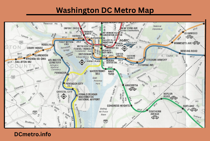
| Feature | Description |
|---|---|
| Metro Lines | 6 color-coded lines: Red, Blue, Orange, Silver, Yellow, Green |
| Major Transfer Stations | Metro Center, L’Enfant Plaza, Gallery Place, Union Station, Rosslyn |
| Total Number of Stations | 98+ stations across DC, Maryland, and Northern Virginia |
| Operating Hours | Mon–Thurs: 5 AM–12 AM, Fri: 5 AM–1 AM, Sat: 7 AM–1 AM, Sun: 7 AM–12 AM |
| Subway Map Format | Tourist-friendly, shows landmarks and accessibility icons |
| Rail Map Format | Detailed route overview with travel time estimates and tunnel markers |
| Station Amenities | Elevators, escalators, bike racks, parking, restrooms |
| Real-Time Apps | MetroHero, Citymapper, Google Maps |
| Map Access Options | PDF download (WMATA), mobile apps (offline access), printed versions |
| Updated For | Silver Line extension, recent station name changes |
DC Metro Station Map
The DC Metro Station Map is your ultimate guide to navigating Washington D.C.’s extensive rail system. Covering six color-coded lines and over 90 stations, this map helps commuters, tourists, and locals easily travel between neighborhoods, landmarks, and major transit hubs. Whether you’re heading to the Capitol, Smithsonian museums, or Union Station, the DC Metro map keeps your journey efficient and stress-free.
The DC Metro Station Map offers a detailed view of all metro stops across the six color-coded lines. It highlights key transfer hubs like Metro Center and Gallery Place, while also showing amenities such as elevators, parking, and bike racks. Ideal for both locals and tourists, it makes route planning simple and accessible.
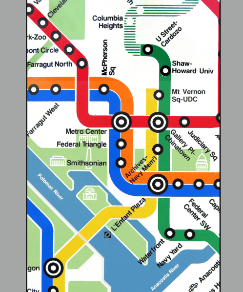
All six color-coded lines (Red, Blue, Orange, Silver, Green, Yellow). Interchange and transfer points like:
- Metro Center (Red, Blue, Orange, Silver)
- L’Enfant Plaza (Yellow, Green, Blue, Orange, Silver)
- Gallery Place–Chinatown (Red, Green, Yellow)
These stations are clearly marked on the map to ensure quick route planning with minimal confusion.
In addition, the map often includes essential commuter amenities:
- Restrooms
- Elevators and escalators
- Parking availability
- Bike racks and Capital Bikeshare stations
This makes the station map ideal not only for locals but also for families, seniors, and travelers with special accessibility needs.
DC Metro Rail Map
If you’re looking for a technical overview, the DC Metro Rail Map is where functionality meets geography. It includes:
- Underground vs. above-ground rail segments
- Distinct line tracks with tunnel indicators
- Travel time estimates between major stations
- Highlighted terminal ends like Shady Grove, Franconia–Springfield, and Wiehle–Reston East
The six lines—Red, Blue, Orange, Yellow, Green, Silver—are represented with color precision and are easy to follow.
Why it matters:
The rail map helps daily commuters prepare for:
- Ventilation differences in tunnels vs. surface stations
- Predicting delays or track work during specific hours
- Timing connections for multi-line travel
For instance, a rider on the Red Line can quickly identify how many stops before Silver Spring or when to transfer at Metro Center for the Blue Line.
DC Metro Subway Map
Perfect for tourists and casual riders, the DC Metro Subway Map focuses on clarity and simplicity. This version prioritizes ease of use with:
Bold, color-coded subway lines. Easy-to-read fonts and large station names Labeled landmarks and museums such as:
- Smithsonian
- National Zoo
- Capitol South
- Arlington Cemetery
It also includes helpful icons for:
- Public bathrooms
- Ticket machines
- Accessibility ramps and elevators
- Park-and-ride facilities
The subway map is often designed in a stylized format (similar to the London Tube or NYC Subway), so it’s tourist-friendly and perfect for printing or saving offline.

DC Metro Stops Map
If someone is looking for the number of stops between Gallery Place and Bethesda? So, finding it by ourself might be a very difficult task for anyone. So, the DC Metro Stops Map comes into picture as it is a super detailed view of:
- All station stops along each metro line
- Interchange stations and transfer options
- Approximate time between each stop
Example:
On the DC Metro Red Line from Shady Grove to Glenmont, there are 27 stops, and it typically takes around 58 minutes to cover the full route.
This map is especially helpful for:
- Planning transfers with little margin for delay
- Meeting friends at mid-point stations
- Managing morning commutes and weekend visits
Make your travel more efficient with these tips:
- Know your transfer hubs: Metro Center, Gallery Place, and L’Enfant Plaza simplify switching lines.
- Check service alerts: WMATA posts maintenance and delays on its homepage and in apps.
- Print the map: A printed version saves phone battery and is helpful for international tourists.
- Use offline apps: Download map layers in Citymapper or MetroHero to avoid signal loss.
- Time your trips: Know the estimated times between stations and plan your transfers accordingly.
Whether you’re commuting daily or exploring DC for the first time, the Washington DC Metro Map—in all its forms (station, rail, subway, and stops)—is an essential tool. It empowers you to:
- Plan routes efficiently
- Navigate between tourist attractions
- Avoid unnecessary delays
- Understand transfer systems
- Enjoy your travel with confidence
The DC Metro Map is more than just a travel tool—it’s your gateway to navigating Washington, D.C. with confidence. Whether you’re commuting to work, visiting iconic landmarks, or planning a weekend adventure, the map helps you move efficiently through the city. With clear layouts, transfer stations, and accessibility features, it’s designed to make every ride smoother, smarter, and stress-free.
Frequently Asked Questions
Ans : Visit the WMATA official website to download high-resolution PDF versions of all metro maps. Mobile apps like MetroHero, Citymapper, and Transit also offer offline access to updated maps.
Ans : The Metro system has 6 main lines, each color-coded:
🔴 Red
🔵 Blue
🟠 Orange
🟡 Yellow
🟢 Green
⚪ Silver
Transfer hubs are available at Metro Center, L’Enfant Plaza, Gallery Place, and Rosslyn.
Ans : Yes. WMATA updates the Subway Map whenever new stations or line extensions are launched—such as the recent Silver Line Phase II extension. Mobile apps usually update within days of official releases.
Ans : These symbols help riders with wheelchairs, strollers, or luggage navigate stations comfortably. They also indicate where you can find:
Public toilets
Escalators or elevators
Parking zones
Bike storage
These features are available on both the station map and subway map.
Ans : Absolutely! Google Maps integrates:
Walking directions to stations
Train schedules
Transfer notifications
Real-time delays
Apps like MetroHero go a step further by showing live train locations and platform crowding levels—ideal during rush hour.
Ans : The DC Metro Subway Map is the best for visitors. It’s simple, easy to read, and includes major landmarks, museum stops, and hotels. Combine it with a tourist pass, and you’ve got a full day of exploring made easy.

